Skip to content
NOWCAST KCCI News at 5am Weekday Morning
Live Now
Advertisement

Growing Mississippi River flood risk this spring, latest central Iowa spring flood risk

normal precip
normal precip
Advertisement
Growing Mississippi River flood risk this spring, latest central Iowa spring flood risk
The spring thaw is upon us here in central Iowa and much of the Upper Midwest. While that thaw means the revival of plants and outdoor activities, it does come with some added risks for our area and regional rivers.The National Weather Service in Des Moines released their updated hydrology outlook for the spring, and there's an increasing risk of major flooding on the Mississippi River. We'll go in-depth on why there's a risk for flooding on the Mississippi and what our flood risk in Central Iowa looks like.While our winter has been characterized as "Moderate" to "Mild" by the Midwest Regional Climate Center, areas to our northwest have seen a "Severe" to "Extreme" winter with several winter storms and more persistent cold temperatures, leading to a thick snowpack.What impact does this have on the Mississippi River? The snowpack is currently deepest in some of the regions of some of the headwaters of the Mississippi River over North-Central Minnesota. A widespread 1-2 feet plus of snow is in place. While this winter season has been active for our neighbors to the north, an abundance of this precipitation has occurred over the last month.Portions of central Minnesota received upwards of 200-300% of their normal precipitation from Feb. 8 to March 8. This could lead to future problems for locations downstream. The National Weather Service is most concerned with the Mississippi River down to Davenport, Iowa, and locations farther south, describing the risk of flooding being "much above normal" with the "potential to be similar to what happened in 2019."While these background conditions already raise the flooding risk, factors that could make things considerably more impactful include a rapid warm-up leading to sudden snowmelt and heavy precipitation during or shortly after the spring thaw.For the Mississippi River at Rock Island, Illinois, which is east of Davenport, there is a greater than 90% chance that the River will exceed 15 feet in mid to late April. There is also a 50-75% chance that the river will exceed 18 feet during this same time, which is considered major flooding.Higher levels are possible if the factors that enhance flooding are met in the next few weeks. For the Mississippi River at Keokuk, probabilities for minor and major flooding are less but still elevated well above normal. Across central and eastern Iowa, the chance of flooding for tributaries that flow into the Mississippi River is neutral to below normal. Over the last 30 days, much of central Iowa has received 100-250% of its normal precipitation which has led to more active streams and creeks compared to what we've seen in the last year. Despite the recent precipitation, minor drought issues continue to linger due to years of inconsistent rainfall dating back to 2020. Parts of central and western Iowa are 75-85% of normal for precipitation over the last 365 days. The latest Drought Monitor still shows pockets of "Abnormally Dry" to "Extreme Drought" over parts of Central and Western Iowa. This recent rainfall is definitely helping to increase soil moisture. We are currently in more of a "replenishing" stage with precipitation than an "aggravating" stage. Flooding is the second deadliest weather-related hazard behind heat. Here are some practical safety tips you can use to protect yourself:Move to higher ground in flood-prone regions.Don't play in floodwaters, as debris and hazardous chemicals may be present.Don't drive into floodwaters. Two feet of flowing water can carry a vehicle away; 6 inches can knock a person off their feet.

The spring thaw is upon us here in central Iowa and much of the Upper Midwest. While that thaw means the revival of plants and outdoor activities, it does come with some added risks for our area and regional rivers.

The National Weather Service in Des Moines released their updated hydrology outlook for the spring, and there's an increasing risk of major flooding on the Mississippi River. We'll go in-depth on why there's a risk for flooding on the Mississippi and what our flood risk in Central Iowa looks like.

Advertisement

While our winter has been characterized as "Moderate" to "Mild" by the Midwest Regional Climate Center, areas to our northwest have seen a "Severe" to "Extreme" winter with several winter storms and more persistent cold temperatures, leading to a thick snowpack.

What impact does this have on the Mississippi River? The snowpack is currently deepest in some of the regions of some of the headwaters of the Mississippi River over North-Central Minnesota. A widespread 1-2 feet plus of snow is in place. While this winter season has been active for our neighbors to the north, an abundance of this precipitation has occurred over the last month.

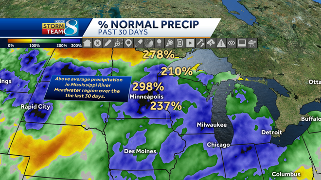
Portions of central Minnesota received upwards of 200-300% of their normal precipitation from Feb. 8 to March 8. This could lead to future problems for locations downstream. The National Weather Service is most concerned with the Mississippi River down to Davenport, Iowa, and locations farther south, describing the risk of flooding being "much above normal" with the "potential to be similar to what happened in 2019."

While these background conditions already raise the flooding risk, factors that could make things considerably more impactful include a rapid warm-up leading to sudden snowmelt and heavy precipitation during or shortly after the spring thaw.

upper midwest current snow depth
Hearst Owned
30-day percent of normal precipitation
Hearst Owned

For the Mississippi River at Rock Island, Illinois, which is east of Davenport, there is a greater than 90% chance that the River will exceed 15 feet in mid to late April. There is also a 50-75% chance that the river will exceed 18 feet during this same time, which is considered major flooding.

Higher levels are possible if the factors that enhance flooding are met in the next few weeks. For the Mississippi River at Keokuk, probabilities for minor and major flooding are less but still elevated well above normal.

Across central and eastern Iowa, the chance of flooding for tributaries that flow into the Mississippi River is neutral to below normal. Over the last 30 days, much of central Iowa has received 100-250% of its normal precipitation which has led to more active streams and creeks compared to what we've seen in the last year. Despite the recent precipitation, minor drought issues continue to linger due to years of inconsistent rainfall dating back to 2020.

Parts of central and western Iowa are 75-85% of normal for precipitation over the last 365 days. The latest Drought Monitor still shows pockets of "Abnormally Dry" to "Extreme Drought" over parts of Central and Western Iowa. This recent rainfall is definitely helping to increase soil moisture. We are currently in more of a "replenishing" stage with precipitation than an "aggravating" stage.

30-day percent of normal precipitation in iowa
Hearst Owned
365-day percent of normal precipitation in iowa
Hearst Owned
latest drought monitor
Hearst Owned
probability of flooding for des moines river at se 6th street
NOAA
probability of flooding for raccoon river at fleur dr.
Hearst Owned

Flooding is the second deadliest weather-related hazard behind heat.

Here are some practical safety tips you can use to protect yourself:

  • Move to higher ground in flood-prone regions.
  • Don't play in floodwaters, as debris and hazardous chemicals may be present.
  • Don't drive into floodwaters. Two feet of flowing water can carry a vehicle away; 6 inches can knock a person off their feet.